Differences in development, new wall construction, and the lasting effects of old barriers create striking contrasts. Here are some amazing images of international borders, taken by astronauts on the ISS, that highlight these striking differences and show how stark man-made divisions can look from space.
Notable ranges visible from space
india vs pakistan
A nighttime panorama taken from the ISS by an Expedition 45 crew member in September 2015 shows India-Pakistan borderThis limit is one of the few International borders visible from space This happens even at night because of the bright security lights installed along the border.
The image also highlights the geographical differences between the two countries, with Pakistan’s rugged terrain appearing in stark contrast to India’s more populated plains. For historical perspective, Alexander the Great crossed the Indus River Valley two millennia ago, a journey that now takes the ISS just three minutes to make.
Image source: NASA
North Korea vs. South Korea
In February 2014, the crew of Expedition 38 International Space Station (ISS) has taken an amazing night photo of the Korean Peninsula. In this picture, North Korea appears almost completely black, with the capital Pyongyang barely visible in the middle.
This dramatic difference in light levels highlights the economic and infrastructure differences between the two countries. South Korea is overly lit, with its major cities shining prominently, while North Korea’s lack of development creates a dark void. The surrounding borders are so dark that they blend seamlessly with the Yellow Sea and the Sea of Japan on either side.
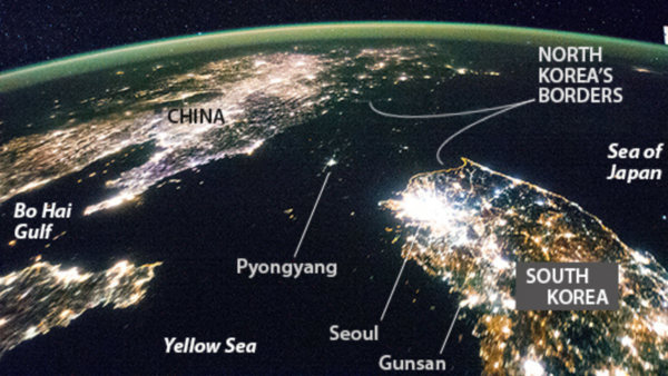
Image source: NASA
Israel vs. Egypt
The photo taken by the Expedition 29 crew from the ISS in November 2011 shows a clear demarcation between Egypt and Israel. A clear line about 30 miles long separates the two countries.
The border is marked by a road, with angular fields to the north reflecting Israel’s commercial agricultural fields. In contrast, Egypt’s lighter soils to the south show the effects of livestock trampling, which has eroded layers of black soil.
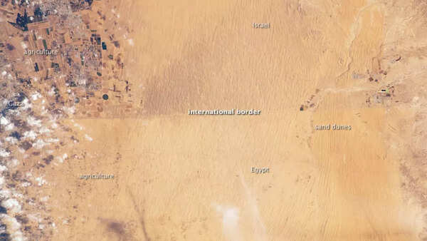
Image source: NASA
East Germany vs West Germany
Despite the fall of the Berlin Wall 25 years ago, the division between East and West Germany remains visible at night. A 2012 photo taken by Andre Kuipers from the ISS shows a notable difference in lighting. The eastern part of Berlin glows yellow, while the western part is green due to the use of more environmentally friendly lighting in that area.
This difference in light quality reflects the economic and infrastructural legacy of the Cold War, with the former East Germany continuing to show signs of its past socialist planning and energy choices, in contrast to the modern progress seen in the West.
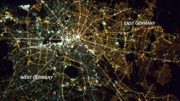
Image source: NASA
Haiti vs. Dominican Republic
A satellite image from 2002 NASA There is a clear difference between Haiti and the Dominican Republic. The Dominican Republic on the right is much greener than Haiti, indicating healthier vegetation. This difference is attributed to deforestation in Haiti, which has led to a more barren landscape.
This image emphasizes the environmental degradation caused by unsustainable agricultural practices and deforestation in Haiti, which stands in stark contrast to the forest conservation and land management policies of the Dominican Republic. This clear ecological divide is one of the most visible and widely known border contrasts from space.
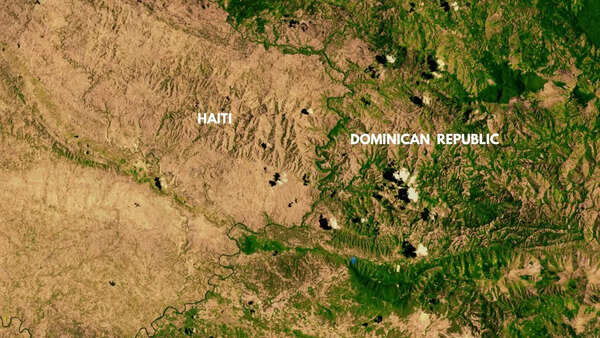
Image source: NASA
USA vs. Mexico
An image taken from the ISS in October 2014 reveals the separation between the US and Mexico due to both the Rio Grande and the border wall. The image shows El Paso, US, near Ciudad Juarez, Mexico. Both cities are heavily developed, while the land near the nearby Franklin Mountain State Park and Puerto de Anapra is dimly lit.
The difference in development between the two countries is clearly visible from space, where the bright lights of US infrastructure contrast with the relatively dim fields on the Mexican side.
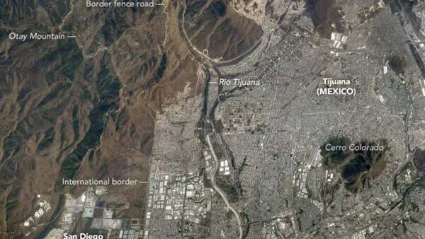
Image source: NASA
Iraq vs. Iran
An image taken by the Expedition 41 crew from the ISS in November 2014 showed several lines along the Iraq-Iran border that appeared to be oil pads. However, it was later determined that these lines were military fortifications. This border area was heavily contested in the 1980s, particularly during Iraq’s defense of the southern city of Basra.
The ongoing conflict and military presence in the region has created clear divisions that can still be seen from space, reflecting the lasting impact of geopolitical tensions on the landscape. The region’s history of warfare has left its mark on both the physical and political geography of the region.
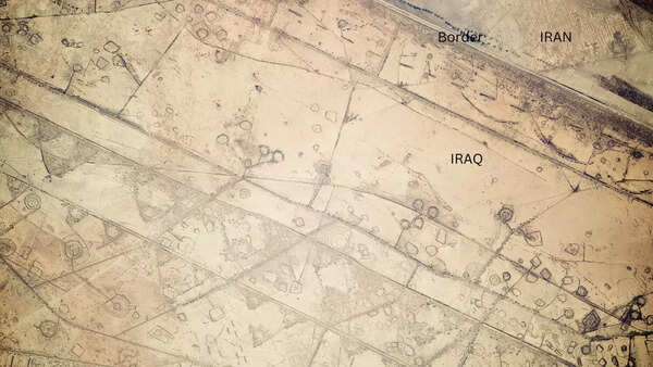
Image source: NASA
Also read: NASA’s stunning images reveal the mysterious surface and atmosphere of Venus


